
Walk the Goodyear Street Directory
An address-first search starts with land, then adds people evidence only where a public record supports it. The Maricopa County Assessor is the fastest official start because an exact Goodyear address can return a parcel number, owner name, situs address, legal description, subdivision, current deed number, and a map link. That is a record of taxable property. It is not a roll of everyone who sleeps there.
Use one stable key at each handoff. The street address reaches the parcel. The parcel number, or APN, reaches the map, tax account, and permit file. The deed number reaches the recorded instrument. A legal description keeps the same lot in view even when postal wording changes.
- Standardize the Goodyear address, then search it in the Assessor roll. Copy the APN, situs address, subdivision or Maricopa County Recorder map number, called an MCR, owner vesting, and current deed number.
- Open the Parcel Viewer. Select the parcel beneath the returned address point, then pan and click each lot along the same street segment.
- Follow the current deed number into the Recorder index. Confirm the parties, recording date, document type, and legal description before moving back.
- Check Goodyear permit records by address or APN. Use a lawful Recorder voter-file request only when registration data is needed at street scale.
- For an older household, use an address or street index in a Valley directory and match the result to census, deed, or vital evidence.
This sequence keeps the Goodyear street directory tied to records instead of guesses. It also makes a failed search useful: if the address is absent, retry the APN, subdivision, project number, older ZIP, or an earlier place name.
Search Goodyear Streets in Assessor
The Assessor accepts one main search term at a time. Official search help says an address may include number, pre-direction, street, abbreviated type, city, state, and ZIP. If a full line fails, omit the city, ZIP, or street type. Directional forms include E, N, W, S, NE, NW, SE, and SW. Owner searches work best with a full first name rather than an abbreviation.
| Assessor mode | Input type | Required rule | Useful format |
|---|---|---|---|
| Parcel number | Text | One search term | With or without separators; a split letter may follow |
| Owner name | Text | One search term | Use the full owner name; do not shorten the first name |
| Street address | Text | One search term | Number, direction, street, short type; omit parts if needed |
| Mobile home | Text | One search term | Owner, address, account, or VIN |
The live entry point is visible in the Maricopa County Assessor property search.

The search screen shows why a precise address, owner name, or APN is more useful than a broad Goodyear surname search. The county also publishes examples of accepted address and APN formats.
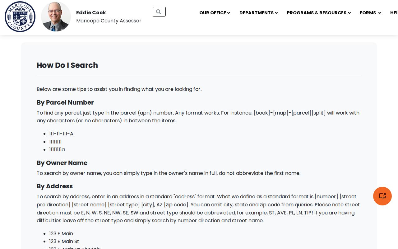
Those instructions support a simple retry tactic: remove extra address parts before deciding that the parcel is missing.
Read Goodyear Street Parcel Results
A parcel card separates the property address from the tax-mail destination. The situs address is the physical taxable location. The owner mailing address is where notices go. A match between them can support an owner-occupancy clue, but it still does not name a full household. A mismatch can reflect another property, a post office box, a trust, an agent, or a business.
The card may also show the APN, current deed number, subdivision or MCR reference, legal description, lot size, class or use, values, sale history, structure facts, and exemption flags. The strongest bridge is the current deed number because it opens the Recorder record without relying on a same-name search.
- Parcel
- A mapped unit of taxable land identified by an assessor parcel number.
- Situs address
- The physical location assigned to the taxable parcel, distinct from the owner's mailing address.
- Plat
- A recorded map that lays out a subdivision, lots, blocks, streets, and an MCR reference.
- Criss-cross directory
- A directory arranged by street and house number so an address can lead to a listed name.
Ownership myth. A Goodyear owner name is not a roster of occupants, family members, or renters at the parcel.
Browse Goodyear Streets in GIS
The Maricopa County Assessor Parcel Viewer turns one address into a street-by-street map. Choose Search By, enter an address, APN, or owner, run the search, select Results, and zoom to the returned point. Click the parcel polygon under that point. Then pan north, south, east, west, or across the street and select each adjoining polygon in turn.
The viewer also searches subdivision names, MCR numbers, section-township-range descriptions, ZIP codes, and map IDs. That matters in Goodyear, where a community name may cover more than one legal plat. Boundaries and parcel clicks are evidence of land next to land. They do not prove that owners are related or that a named owner lives on site. The county's Parcel Viewer location instructions show the search and result flow.
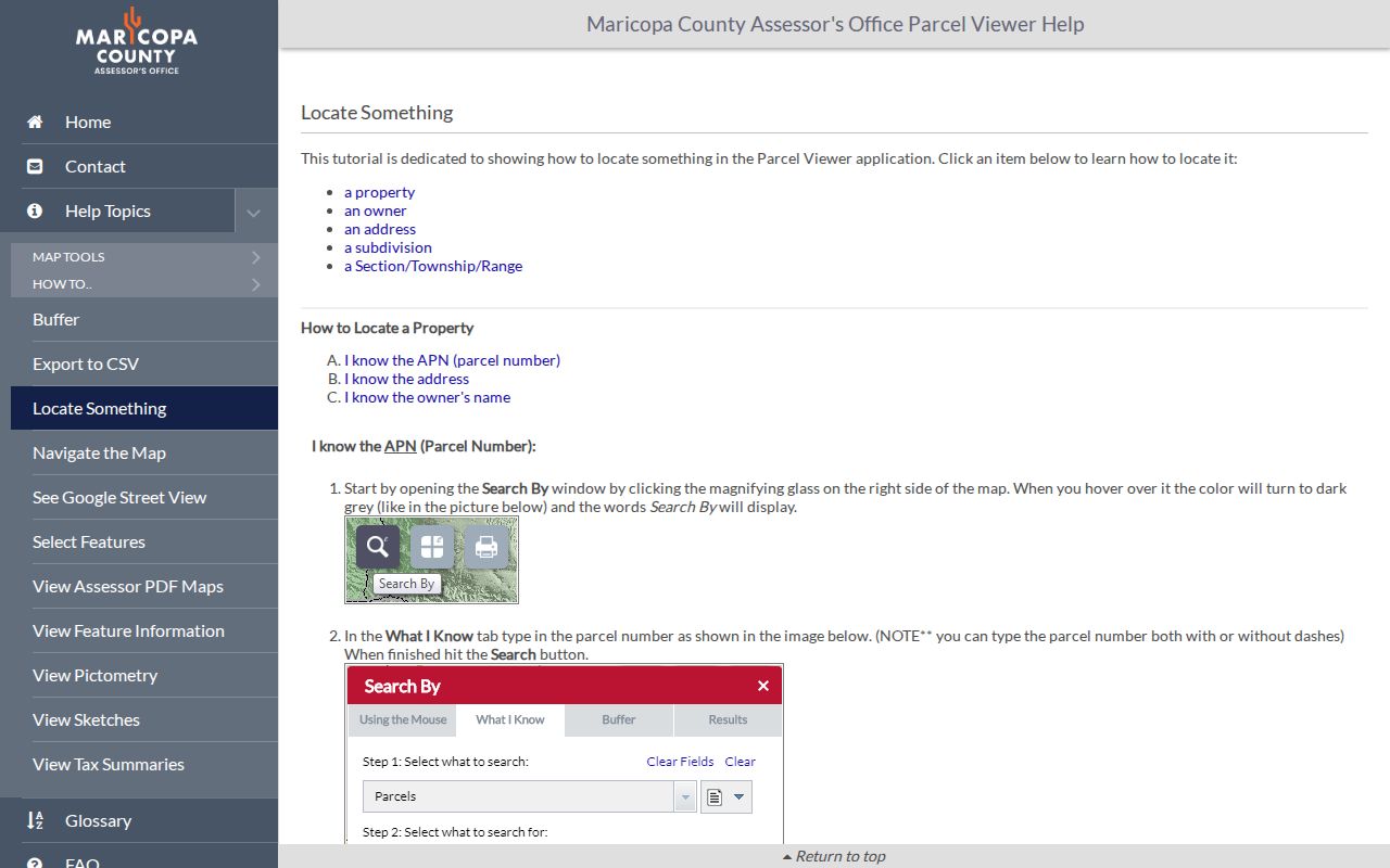
The illustrated flow makes the key map step clear: select the result, then identify the parcel beneath the address point before reading adjacent lots.
Note: Map ownership follows the Assessor roll's timing, so record the tax year or retrieval date when comparing Goodyear parcels.
Chain Goodyear Records by Street
No single Goodyear office holds every address fact. The Assessor owns the current parcel roll, the Recorder keeps instruments, the Treasurer handles tax accounts, and Goodyear Development Services holds city permit and project records. The address and APN tie those systems together.
| Address record | Official keeper | Street evidence | Access route |
|---|---|---|---|
| Current parcel roll | Maricopa County Assessor | Owner, situs, mailing, APN, legal, deed number, structure | Free web search or county counter |
| Parcel map | Assessor GIS | Boundaries, nearby parcels, ZIP, subdivision, land grid | Free viewer and map browse |
| Deed or affidavit | Maricopa County Recorder | Transfer parties, date, legal description, and value when filed | Free index/image; paid official or certified copy |
| Plat | Recorder and Assessor | Lot, block, street layout, and MCR | Document or parcel search |
| Permit or project | Goodyear Development Services | Address, work, date, applicant or contact, and status | Accela, counter, phone, or records request |
| Tax account | Maricopa County Treasurer | Bill, payment, or delinquency keyed to APN | Free parcel/account lookup |
A strong Goodyear address result preserves labels. “Owner” is not changed to “resident.” “Applicant” is not changed to “occupant.” Each fact keeps the date and role its custodian gave it.
Goodyear Plats Anchor Street Identity
Goodyear assigns subdivision addresses after a final plat is recorded. Suite addresses arrive during building review. This sequence explains why an early planning or land record may use a parcel, project, subdivision, lot, or MCR number before the modern street or suite appears.
When an address search goes quiet, search the subdivision as a Business Name in the Recorder and choose the Plat Maps document code. The Recorder search guidance recommends shortening a subdivision term if the full name fails. Then match lot and block on the plat to the legal description on the parcel card. That link is safer than relying on a marketing name used across several phases.
Goodyear Development Services address standards also explain the development-counter channel. The city aligns address work with Maricopa County survey control, while the recorded plat remains the durable street-layout source.
Extend Goodyear Streets Through Deeds
The Maricopa County Recorded Document Search does not offer a clean house-by-house street list. Start with the deed number from the Assessor. The result can show indexed people or businesses, document number, recording date, document code, page count, and an unofficial image. An Affidavit of Property Value may show a sale date and price, though an exemption code can leave price absent.
To move backward, note the seller, then search that person or business as an earlier buyer. Confirm the same legal description, subdivision, or parcel link before accepting the match. Trust and company ownership calls for the Business Name field. The Recorder reports more than 52 million documents, but its inspected official pages do not state the exact earliest online year.
Unofficial images are free. Official copies cost $1 per page, and certification adds $3 per document. The downtown Phoenix Recorder counter and 602-506-3535 are the fallback for older indexing and copy help. Ask about deed books or offline indexes rather than guessing a cutoff.
Note: The Assessor's current deed number is usually the shortest path to the transfer, while Recorder Title Alert monitors later recordings.
Search Goodyear Permits by Address
The Goodyear Development Center points to Accela for project information, permits, inspections, and code-compliance activity. Public search fields include record number, date range, record type, street number, direction, street name, type, unit, parcel number, and sometimes person or organization fields. An account is needed to submit or manage owned applications, not necessarily to find project status.
A permit dates proposed or approved work. It can help explain when a structure, room, pool, or suite changed. Yet the applicant might be an owner, contractor, architect, or agent. It does not prove who lived there. If the portal lacks an older file, contact Development Services at 623-932-3004 or use the city's public-record request channel for a narrow address, APN, record type, and date range.
Request Goodyear Voter Street Records
The Arizona Voter Information Portal checks a voter's own status, districts, notices, ballot-by-mail status, and participation history. It cannot enumerate a Goodyear street. Street-scale work uses the Maricopa County Recorder voter-file request under A.R.S. §16-168.
A VM51 file can be bounded by district and status, then filtered by delivered address fields. It may include name, registration date, addresses, party, phone, early-voting-list flag, status, and participation history. The file has statutory fees and arrives through a secure link after invoicing. The layout supplied with it controls how residence and mailing fields should be read.
Protected voters under A.R.S. §16-153 and Address Confidentiality Program participants are omitted. An inactive status does not prove a move, and voting history never reveals a ballot choice. Do not try to rebuild protected addresses through nearby entries.
Bridge Goodyear Street ZIP Changes
Goodyear's 85395 ZIP took effect July 1, 2007, when 8,478 delivery addresses changed from 85338. A present-day northern Goodyear address may therefore appear under 85338 in an older deed, permit, directory, phone book, or item of correspondence. Search both ZIPs around the transition before treating either version as an error.
Postal Goodyear, municipal limits, parcel situs, and service areas are separate layers. First standardize a mailing line through USPS. Then confirm the APN and city relationship through county or city GIS. The Parcel Viewer can search a ZIP layer, but ZIP alone does not prove ownership, occupancy, or city jurisdiction.
Note: Keep the APN and legal description beside both ZIP versions because those land keys survive postal changes better than a mailing line.
Read Old Goodyear Streets Differently
A historical address index is a Valley search. Goodyear's post office and name date to 1944, and the town incorporated in 1946. Earlier people and places may appear under Litchfield, Avondale, a rural route, Southwest Cotton Company, or Phoenix and Salt River Valley headings. Modern Goodyear spelling may miss the right entry.
The Arizona Memory Project directory collection includes digitized city and business volumes from the 1880s through the 1960s, while its wider genealogy corpus spans 1881 through 1989. When a volume includes a street index, begin with the street heading and house number. Then open the person's alphabetical entry for more detail. The exact years of any Goodyear-only criss-cross run were not verified.
OCR may split words and misread route abbreviations. Browse the page image when a text search fails. For print or undigitized years, call the State Research Library Reading Room at 602-926-3870. Georgia T. Lord Library at Civic Square, 602-652-3000, can check the county library catalog and make referrals, but its public page does not confirm a local criss-cross shelf. The full collection history and reading methods belong to the Goodyear city directories resource; here, the address index is used only as one step in a street search.
Respect Goodyear Street Directory Limits
The Goodyear street directory cannot provide a complete household list. Tax records usually name titled owners, not renters or family members. Permit contacts may not occupy the site. A voter file excludes protected people and does not include every resident. Telephone and historical directories cover listed subscribers or the scope chosen by their publishers.
Motor-vehicle addresses are restricted by the federal Driver's Privacy Protection Act. City utility and delivery records are not public neighbor rosters. An omitted name may reflect privacy protection, source scope, timing, or ordinary indexing error. It must never be treated as an invitation to search around a safeguard.
Lawful use. Goodyear address records support family history, property research, civic review, and personal safety. Arizona law does not permit stalking, harassment, threats, or intimidation with public information.